
Today was the last dive at Axial Seamount to survey one of the secondary cables and pick up the junction box we used for testing before we batten down to transit 18 hours east to the RSN Slope Base site along the continental margin. If the weather and sea conditions hold there, ROPOS will latch the last remaining cable reel to its belly and lay 500 meters of cable on the sea floor.
Planning secondary cable routes is one of co-chief scientist Giora Proskurowski’s jobs on the VISIONS ’13 expedition. For Axial Seamount, where 18 km of secondary cable have been laid, the effort really started two years ago. Using detailed bathymetry maps created in 2011 by the Monterey Bay Aquarium Research Institute and the University of Washington, Giora and colleagues mapped the cable routes from the primary nodes to the equipment junction boxes. Like surveying a road, Giora used the terrain maps to avoid obvious hazards, like steep cliffs and rough patches of lava, which can drag down or snag the bright orange cable. The cable lengths were then calculated, with slack to allow for uneven terrain, and the orders placed with the cable vendor.
At that point, Giora’s job was by no means finished, and he’s been busy on the R/V Thompson with fine-tuning the cable-route planning. Even with the detailed bathymetric maps, there are some features and bottom textures that you can only see by flying over them with an ROV. So, the ROPOS crew and scientists survey the pre-planned cable route prior to actually laying the cable, paying close attention to potential landing spots at the ends and marking them with round numbered identifiers. Sometimes, says Giora, you have to hold your nose going over rough patches and stick with the pre-planned route since the cable lengths have already been cut. Other times he tweaks the route to avoid hazards, but the routes are always changed to some extent because the landing and starting points can only be determined on site during the survey dive.
The trickiest scenario is when a new route is longer than the pre-planned route because you always want to plan for slack to prevent the cable from being stretched and forming a “hockle” or kink in the cable. When a hockle is severe it can disrupt the fiber optics inside, as we found in Dive 1617 when testing showed that the cable had a discontinuity at the site of the hockle.
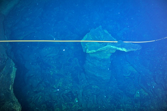
Cable laying is actually cable dropping. ROPOS flies 20-30 meters off the sea floor releasing cable to float down to the bottom and out of sight. Once ROPOS unwinds cable from the reel, the cable’s fate is not known until the ROV goes back and surveys the cable lay. On a survey during Dive 1619, the cable was found draped elegantly over two pillars rising from a collapse pit. That couldn’t have been planned, but the sight pleased the science team and ROPOS, like hitting a hole in one on the golf course.
Written by guest contributor, Mary Miller, Exploratorium