
The four legs of the VISIONS’13 expedition took place from June 30 to August 29, 2013 onboard the 274’ UW-operated research vessel Thomas G. Thompson (TN299) utilizing the Canadian remotely operated vehicle (ROV) ROPOS. The cruise was funded during the construction phase of the National Science Foundation’s Ocean Observatories Initiative (OOI).

ROPOS enters the water on dive 1604 during VISIONS’13. Photo Credit. Mitch Elend.
The 48-day Regional Cabled Array (RCA) expedition included 53 dives by ROPOS. The cruise completed all objectives, which focused on preparations for completing the installation of the RCA in 2014, which included the installation and connection of secondary nodes, > 140 instruments, and moorings at the five study sites. The cruise was highly successful with the installation of 22,000 meters of extension cables that allowed follow-on connection in 2014 of all RCA junction boxes, moorings, and instruments to the Primary Nodes and high-power and high-bandwidth fiber optic cables that bring the Internet from shore into the ocean. All extension cables have been fully operational since 2013.

Numerous spools of extension cables deployed on Leg 3.
Because of the intense cable-laying component of this cruise, ROPOS used their specialized Remotely Operated Cable Laying System (ROCLS). Cable installations included 12 cables, the longest of which was ~ 5 km in length. Post lay inspections were completed on all cables. Key to the cable laying success was extensive cable route surveys and planning in 2011, with included the development of 5 m resolution bathymetric maps. Another highly important component was providing detailed cable routes to the ROPOS navigation team along with slack calculations at each way point and kilometer way points (we provided in meters) matched with layer markings on the drums. In concert, these data provided knowledge of exactly how much cable was laid out at each point.

This short-period seismometer was deployed on a flat sheet flow ~ 1.3 km east of the ASHES hydrothermal field in 2013. The black ball in the yellow circle shows that it is perfectly level, helping to insure that the highest quality data comes off of this network. Several earhquakes were detected in real-time during testing of these seismometers in 2013. Photo credit: NSF-OOI/UW/CSSF.
Key installations during this program included:
- Over 22,000 m of fiber optic extension cables on the seafloor — all tested and functional
- Three medium powered junction boxes (Slope Base – MJ01A; Axial Summit – MJ03B, and MJ03E) – all tested and functional
- Four short-period seismometers at Axial – all tested and functional
- A high definition video camera at the ASHES hydrothermal filed – tested and functional
- A 3D thermistor array at ASHES – battery powered for the first year.
- A bottom-pressure tilt sensor near Eastern Caldera – which was cabled and tested in 2014- has been fully operational since 2014.
- 2 pressure sensors (Slope Base and Axial Base) – 1 tested and functional; 1 connected in 2014 – both were operational in 2014
- 2 benthic flow meters at Southern Hydrate Ridge – recovered and reinstalled in 2014.
- 2 caissons (Southern Hydrate Ridge summit and Slope Base) with broadband installations completed in 2014 (all operational since turned on in 2014).
The installations at Axial include three nearly complete subnets, both of which were fully tested by powering them up and communicating to them with ROPOS – both were shown to be fully operational.
1) The first subnet was installed at the ASHES vent field and includes a 4 km cable extending from near Primary Node PN3B and connected to the Medium powered J-Box (MJ03B) within the field. This J-Box includes connections to a 1.3 km extension cable across the caldera connected to a short-period seismometer and a 50 m extension cable with another short-period seismometer. A battery-powered thermistor array was also deployed there for a 1-year test.

2) The second subnet was also in the ASHES field and includes another 4 km cable (10 Gbs) extending from near PN3B, which is connected to the high definition camera at the base of the actively venting Mushroom hydrothermal chimney.
3) The third subnet was installed at Eastern Caldera and is a geophysical array to monitor seismicity within the volcano and inflation and deflation of the seafloor. Installed infrastructure at this site included a 635 m extension cable from near PN3B that is connected to MJ03E. Two short-period seismometers are connected to the J-Box via a 1262 cable and a 581 m cable, respectively. In 2014, the bottom pressure-tilt instrument and a broadband seismometer with a hydrophone were installed, completing this subnet.
4) The fourth subnet is located at the Slope Base site, which includes a 576 m cable extending from near Primary Node PN1A to the J-Box MJ01A, and a cabled current meter and pressure sensor. In 2014, a broadband seismometer, also hosting a hydrophone, was installed and connected at this site (there is already a caisson there).
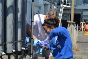
A break in the overcast days brings on great sunny weather for sampling water from the CTD. Photo Credit: Mitch Elend, University of Washingotn.
The UW OOI team of oceanographers, engineers, and educators took nineteen undergraduate and graduate students to sea with them, providing immersive experiences in sea-going operations, research, and science communication. As with will all RCA cruises, live HD video was streamed to shore from the ship and seafloor via satellite during the cruise. Other highlights of the program included the detection of earthquakes during testing of both the ASHES and Eastern Caldera subnets (followed by analyses of the earthquakes by William Wilcock, University of Washington and students while at sea aboard the Oceanus), streaming of live HD imagery for several hours to the Internet from the seafloor camera deployed at the ASHES vent field, and documentation of profound geological and plume changes at the Southern Hydrate Ridge site with large, recent collapse zones and very intense bubble plumes.