Image Archive











On August 8, 2014 all secondary infrastructure at the summit of Axial Seamount was connected to the Primary Infrastructure. Image Credit: University of Washington, V14.

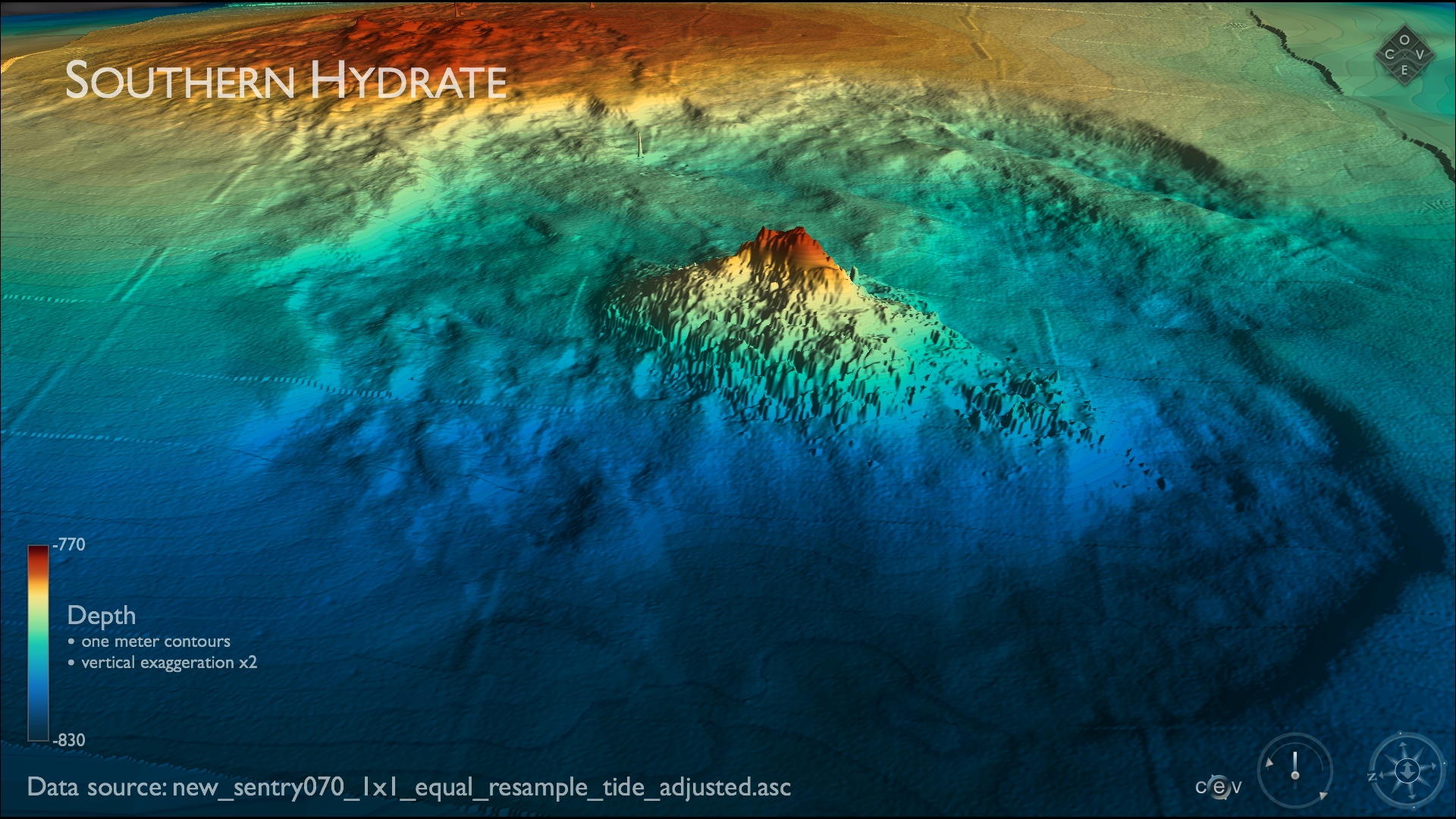
Southern Hydrate Ridge is located ~ 100 km west of Newport Oregon at a water depth of 780 m. Credit: University of Washiington, Center for Environmental Visualization.

The carbonate bioherm at Southern Hydrate Ridge rises ~ 60 m above the seafloor. Credit. University of Washington, Center for Environmental Visualization.

Hydrate 3

The carbonate bioherm at Southern Hydrate Ridge rises ~ 60 m above the seafloor. Credit. University of Washington, Center for Environmental Visualization.

Hydrothermal

Endeavor Vent Field

Vent Field Mechanics

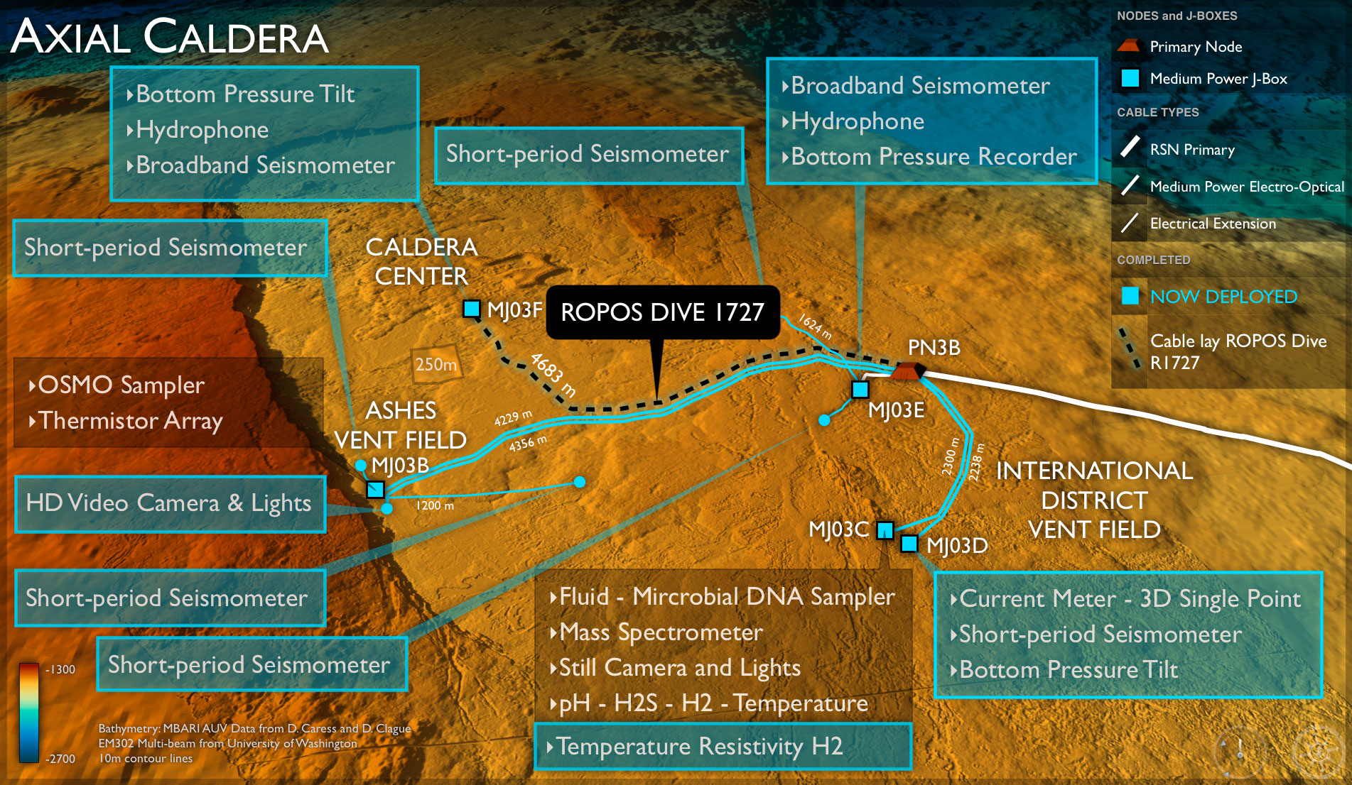
Axial Caldera ROPOS Dive 1727

All Secondary Infrastructure is now installed and connected to junction box MJ03D – it awaits connection to Primary Node PN3B. a) The bottom pressure-tilt instrument (BOTPA303) is slung beneath the ROV ROPOS for transport to the seafloor. b) Final installation image of the short-period OBSSPA305 connected to MJ03D. c) The current meter (VEL3DB304) being placed into its final location by the ROV ROPOS. d) Final placement of the bottom pressure-tilt instrument (BOTPTA303) installed and connected. Image Credit. Debbie Kelley, University of Washington, V14.

During Leg 1 of the OOI-NSF VISIONS'14 Expedition, we are making significant progress in the installation of secondary infrastructure at the summit of Axial Seamount. Infrastructure shown in green is deployed on the seafloor. During ROPOS Dive R1727, the ~ 4.6 km extension cable from PN3B to MJ03F at Central Caldera will be installed, completing this site. Image Credit: University of Washington, V14.

A composite of ocean circulation, seafloor bathymetry, tectonic plate boundries, and world population. Composite created by Center for Environmental Visualization.

Safety Advisory Image Example 2

Safety Advisory Image Example

A new generation of marine research and oceanographic discovery in the San Juan Islands

Visions'14 Application Image

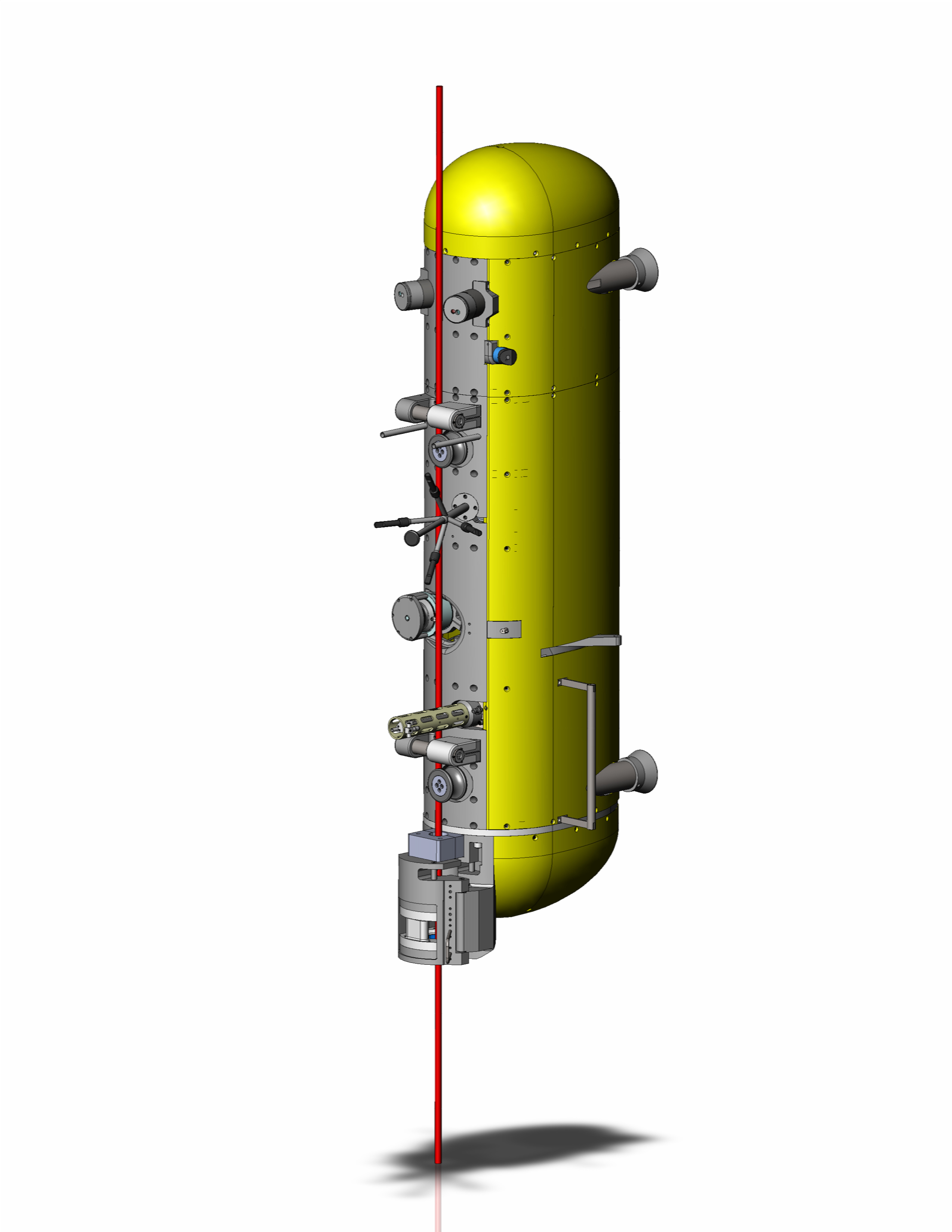
The RSN Deep Profiler (DP) system is designed to collect oceanographic data profiles in water depths of up to 3000m. The DP system includes a modified McLane Mooring Profiler (MMP) vehicle that uses a motor traction drive to profile from near the sea surface to the seafloor along a tensioned mooring cable with a subsurface float. The system's dock assembly near the seafloor includes an inductive battery-charging dock for the vehicle battery, an inductive communication system that provides communications during profiling, and a Wi-fi antenna that provides high-speed communications while in the charging dock. The dock electronics will connect to the RSN power and fiber-optic data network using ROV-mateable underwater connectors. (Illustration by Nick Michel-Hart, University of Washington)

AGU 2013 Poster Final

During the VISIONS'13 Expedition, three subnets were completed at this site (highlighted in blue). They include: 1) a medium-powered J-box MJ03B in the ASHES hydrothermal field, which is connected to two short-period seismometers; 2) an HD camera also in the ASHES hydrothermal field; and 3) a medium powered J-box MJ03E connected to two short-period seismometers. Over 20 km of extension cables, with lengths up to ~ 5 km, were successfully installed in 2013 using the ROV ROPOS. All extension cables and subnets were fully tested and are functional, awaiting to be connected to Primary Node PN3B. The remaining infrastructure will be deployed in during VISIONS'14, next year.

The summit of Axial Volcano will host myriad geophysical, chemical and biological instruments connected in real-time to the Internet via an array of junction boxes and extension cables. During the VISIONS'13 Expedition, three subnets were completed at this site (highlighted in blue). They include: 1) a medium-powered J-box MJ03B in the ASHES hydrothermal field, which is connected to two short-period seismometers; 2) an HD camera also in the ASHES hydrothermal field; and 3) a medium powered J-box MJ03E connected to two short-period seismometers. Over 20 km of extension cables, with lengths up to ~ 5 km, were successfully installed in 2013 using the ROV ROPOS. All extension cables and subnets were fully tested and are functional, awaiting to be connected to Primary Node PN3B. The remaining infrastructure will be deployed in during VISIONS'14, next year.

Fredrik Ryden created a prototype 3D visualization of ROPOS dives for his student project. This image shows 15 dives simultaneously on Axial Caldera's bathymetry. The black lines are the RSN cable routes extending from Primary Node PN3B (on the lower right of the image).

axial_overview Credit: Fredrik Ryden

axial_firstpreson Credit: Fedrik Ryden

A variety of geophysical sensors will be deployed at the base of Axial Seamount to monitor seismic events on the Juan de Fuca plate.

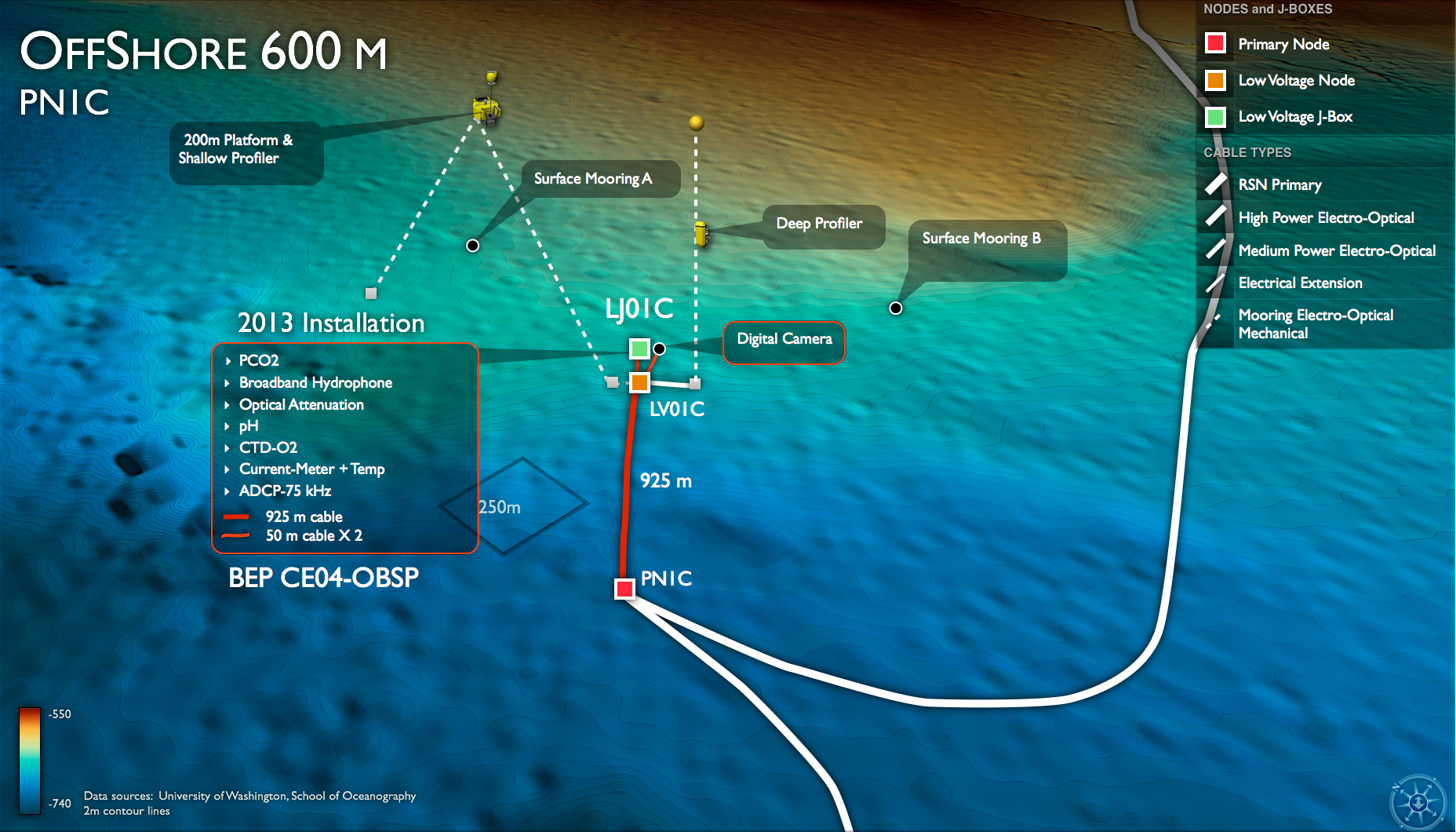
The Offshore Endurance site at 600 m water depth will host two cabled moorings and a Benthic Experiment Platform with numerous physical, chemical and biological sensors, as well as a digital still camera.

Preparing to "capture" an underwater volcano in the northeast Pacific Ocean.

V'13 Expedition Main Image

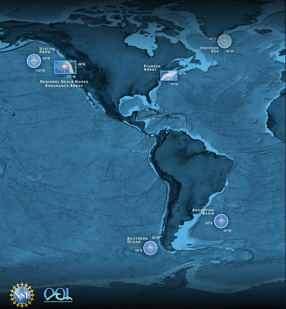
Locations NSF's Ocean Observatory Initiative Sites. Credit: University of Washington, Center for Environmental Visualization.
- Anemone
- Animal
- Arthropod
- ASHES
- Axial
- Axial Base
- Axial Biology
- Axial Caldera
- Bacteria
- Basalt Lava
- BEP
- Biofouling
- biolgoy
- Biology
- Camds
- Camera
- Camhd
- Central Caldera
- Ciliates
- Cnidaria
- Coastal Biology
- Crab
- Deep Profiler Mooring
- Dive Highlights
- Eastern Caldera
- Echinoderms
- Endurance Array
- Engineering Team
- ENLIGHTEN 10
- Exploratorium
- Fish
- Geology
- HD Camera
- HPIES
- Hydrate Ridge
- Hydrates
- Hydrophone
- Hydrothermal Vents
- Illustration
- Inshore 80 Meters
- Instrument
- International District
- J-BOX
- Jason
- Jellyfish
- Junction Box
- K12
- Lava
- Mollusk
- Moorings
- Nodes
- Nudibranch
- Octopus
- OOI
- Oregon Offshore
- Oregon Offshore 600 m
- Oregon Shelf
- Oregon Slope Base
- People
- PN1B
- PN1D
- Polychaetes
- PPSDN
- Primary Node
- RASFL
- ROCLS
- ROPOS
- ROPOS Dives
- ROV Team
- RV Revelle
- RV Sikuliaq
- RV Thompson
- Salp
- Sample
- SC13
- Science Team
- Sea Cucumber
- Sea Star
- Sea Urchin
- Seafloor
- Seismometer
- Sensors
- Shallow Profiler Mooring
- Shark
- Shipboard
- Shore Station
- Slope Base
- Smoker
- Soft Coral
- Southern Hydrate Ridge
- Sponge
- Squid
- Students
- Students & Guest Participants
- Tmpsf
- Tubeworms
- VISIONS 11 Leg 1
- VISIONS 11 Leg 2
- VISIONS 11 Viewers
- VISIONS 13
- VISIONS 14
- VISIONS 15
- VISIONS 16
- VISIONS 17
- VISIONS 18
- VISIONS 20
- VISIONS 22
- VISIONS 23
- Visualization
